Click on photo to enlarge
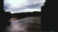
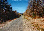
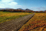
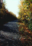
The Restigouche Trail has its western entrance at the Upsalquitch River (on the old International Railroad - INR bridge). It crosses the river, with a spectacular view of of the famous salmon fishing river, and enters the forest to continue along the abandoned rail line. Adequate signage indicating distances has been erected to NB Trail Council standards. The trail bed in this section consists of railroad ballast rock that has been crushed and compacted. It is suitable for cycling (mountain bikes) or walking, but certain sections may be rough as the compacting has eroded. A shelter is accesible at 2km from the bridge (snowmobile club shelter). At 17km, in Glencoe, The Restigouche Snowmobile Club clubhouse is sometimes open on weekends or for special activities. From this point on, the trailbed is of compacted crusher fine and ideal for walking and cycling (mountain bike or hybrid). The trail is along the banks of Christopher Brook. Trout fishing is permitted. (NB fishing licence is required).
In the village of Tide Head (km 21), trail users are in proximity to Tide Head Beach, a gathering place for local fishing enthusiasts and canoers of the Restigouche River. The trail crisscrosses the scenic village and local amenities, such as a convenience store, Bed & Breakfast, restaurant and garage are all situated along the trail.
In the village of Atholville (km 25), the trail enters the Ducks Unlimited Conservation Area. This is a marsh area on the Restigouche River where several species of birds congregate to take advantage of the tidal flows of the estuary and the abundance of food it provides. The Margaret Doyle Lookout is placed at a vantage point for bird watchers. Spectacular sunsets overlooking the river and Appalachian Moutains of the Gaspé Coast are a delight for nature lovers and photographers.
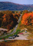
Sugarloaf Provincial Park (km 30) is situated on the boundary of Atholville and the city of Campbellton and nestled at the base of Sugarloaf Mountain (elevation of 929 ft). It is a NB Year Round Activity Destination offering a full compliment of camping services and activities for the whole family. The Terry Fox Memorial Trail (4 km) circles the base of Sugarloaf and acts as an entry way to the city at the eastern end of the trail.
The City of Campbellton (km 32) is on the southern bank of the Restigouche river opposite the Quebec Gaspe coast to which it is linked by the JC Van Horne interprovincial bridge. The trail leaves Sugarloaf Park and is but 6 km along the banks of Walker Brook to Salmon Boulevard along the city waterfront. This section is in the final phases of construction and users are advised to proceed with caution as some work may be in progress during the summer months.
Note: The section of trail from Campbellton to McLeods (10km) is still at the planning stage.
The section of trail from Upsalquitch River to Tide Head is accessible only to snowmobilers during winter months. Other sections may be open to various winter activities as local interest is gathered and coordinated with M.P.T.A.
 >
>
 >
>
 >
>
 >
>
 >
>